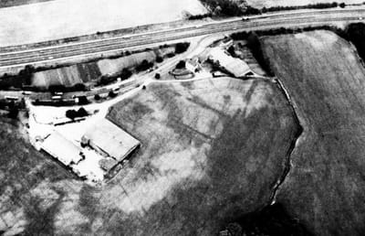
The Roman Forts
This aerial photograph, (Derek Riley 1970s), shows the two stages of Roman forts built at the side of the original Roman road to the North, (now the A1).
This was most likely still a prominent feature in the landscape when the Domesday Survey was taken in 1086 and so led to the parish being called 'Burg'.
This was most likely still a prominent feature in the landscape when the Domesday Survey was taken in 1086 and so led to the parish being called 'Burg'.